Traveling To Tahoe For Thanksgiving? Be Prepared For Snow & Wind
KPIX 5 Morning Weather Anchor Roberta Gonzales answers the questions you never get to ask on-air.
Q: Roberta, do you think we will make it over the mountain if traveling to Tahoe Tuesday or Wednesday? We go Highway 50 to South Lake Tahoe. We want to leave Tuesday morning. Part of our group can't leave until Tuesday at noon. It is typically a four hour drive for us, so our noon group would be headed over the pass at approximately 4:00 pm Tuesday. What do you think? -Cathy Brink; Danville
A: One of the most difficult parts of my job is to answer questions like this. If I say, GO and traffic delays you, then all of a sudden the storm has caught up with you and you are driving in heavy snowfall. The circumstances would then be out of my control, causing forecast to be incorrect! And you would be cursing my name all the way to Tahoe!
Let me give you an outline of how I see weather events unfolding. I hope you use this information to plan carefully and accordingly. Drive safely!
Please be mindful timing can change!
Monday: Mostly cloudy and cooler. Breezy. Highs 58 to 65. West winds 10-15 mph.
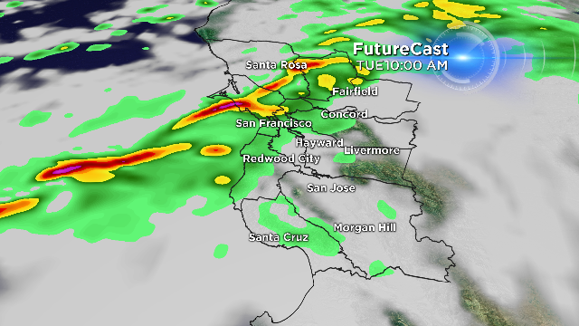
Tuesday: Rain develops in the morning in the North Bay, Central Bay by noon, South Bay by early afternoon. Cool. Highs 53 to 58. West wind 10-20 mph. King tides peak Tuesday morning around 8:45-9:34 AM. 6.77 ft. Then, 11:03 PM at 5.14 feet.
Tuesday overnight to Wednesday 12:00 a.m - 3 a.m: More showers with cold air. Snow level locally down to 2,500 feet.
Wednesday: A spotty lingering morning shower. Gradual clearing. Highs in the 50s. King tides peak Wednesday around 9:27-10:16 a.m. at 6.86 feet.
Wednesday overnight: Lows in the upper 20s and low 30s inland, 30s and 40s in the Bay Area and on the coast. Frost and black ice likely.
Thanksgiving: Partly sunny with highs in the 50s.
King Tides: Thursday around 10:09-10:59 a.m. at 6.81 Ft.
Black Friday: Sunny and highs in the 50s.
TAHOE REPORT: A Winter Storm Watch is in effect from Tuesday morning through Wednesday afternoon. A foot of more of snow is possible above 7,000 feet with 5 to 10 inches at lake level.
Those traveling in the Sierra on Tuesday and Wednesday should consider alternate routes and/or departure times. Carry emergency supplies and be prepared for long travel delays. Those heading to ski resorts should dress for very cold temperatures and strong winds.
I would love to hear from you! Please send weather questions, observations and photos to me, Gonzales@kpix.cbs.com and I look forward to hearing from you!