New Storm Moves In To Northern California, Threatening More Flooding
SAN FRANCISCO (CBS SF) -- The first outer rain bands from a powerful Pacific storm headed to Northern California on Sunday brought light rain and wind and renewed warnings of possible flooding in the already soggy region.
The San Joaquin River at a measuring station near Vernalis remained at "danger stage," meaning it keeps approaching the top of levees, said Tim Daly, a spokesman with San Joaquin County Office of Emergency Services.
"When the water gets that high and more water is coming, there is just too much pressure and levees can break. They can be topped," Daly said.
Daly says residents of low-lying areas have been told to be ready to evacuate, especially those in San Joaquin River Club, a riverside, private neighborhood of 800 homes 10 miles south of Tracy.
Residents of the community have been constantly patrolling the levees for signs of danger and holding meetings to discuss evacuation routes and preparedness, said Paula Martin, who is helping coordinate evacuation plans.
"We have a levee response team, a sand bagging team, teams to check on what walkers checking on the levees find," Martin said. "Our community is pulling together like real champs."
Meanwhile, the water level was decreasing at Lake Oroville dam, where a damaged spillway had raised major flood concerns.
Nobody was hurt as crews used boats to rescue residents from a low-lying neighborhood.
"We're telling those people to keep a bag close by and get ready to leave again," Saso said. "If the water comes back up, it's going to be those areas affected."
Another round of heavy rain was expected to move in overnight Sunday and forecasters said several inches were expected.
"Widespread flooding will be likely as an atmospheric river (of moisture) takes aim somewhere along the central California coast," the National Weather Service said.
The damage to the spillway at Lake Oroville forced the evacuation of 188,000 people last weekend.
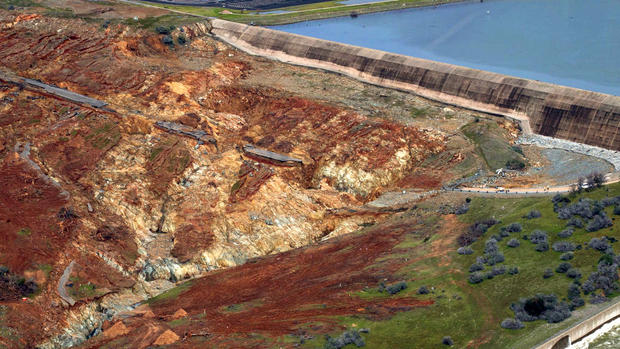
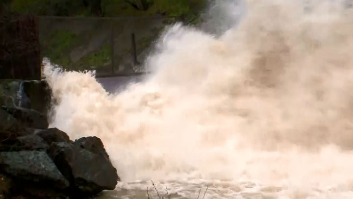
The California Department of Water Resources said Sunday that the water level continues to fall even as they decrease the amount of water flowing down the spillway.
The amount of water flowing down the spillway was increased from 55,000 cubic feet a second (cfs) to 60,000 cfs Sunday afternoon in anticipation of the storm. Earlier this week, outflows were at nearly 100,000 cfs.
During recent storms, authorities up and down the state have dealt with overflowing creeks, mudslide threats in foothill areas blackened by fires, road collapses and hundreds of toppled trees in neighborhoods. At least three deaths have occurred.
Most of Southern California appeared to dodge any major disasters in heavy rain on Friday. But in the desert town of Victorville, several cars were washed down a flooded street and one man was found dead in a submerged vehicle after others were rescued, authorities said.
In the Sherman Oaks area of Los Angeles, a man was electrocuted when a tree falling in heavy rain downed power lines that hit his car.
On Saturday, searchers found the body of a man in his 20s who was swept down a rain-swollen gully in Thousand Oaks a day earlier. Three other people stranded by the water were rescued.
BAY AREA
The Anderson Reservoir near Morgan Hill was overflowing and at more than 100 percent capacity -- well beyond its seismic safety limits if a major quake should hit.
The storm runoff and dam water releases were clogging the San Francisco Bay with debris and also beginning to concern biologists about the delicate salt water/fresh water balance in the ecologically sensitive waters.
The San Francisco Bay Ferry service that commutes thousands daily from Oakland, Vallejo, Alameda and South San Francisco has had four of its ultra-modern boats damaged by the debris in the last three weeks causing service disruptions.

The National Weather Service has issued a Flood Watch through Monday night for the entire Bay Area.
Forecasters said rainfall amounts of 4 to 7 inches will be possible along the coastal ranges with the potential for some locations to see upwards of 10 inches.
Meanwhile, North Bay valley locations, coastal areas in and around the San Francisco Bay Area and areas around Santa Cruz have the potential to receive 2 to 5 inches of rainfall through Monday night.
Winds will also be a factor, the weather service said, with sustained southerly winds 20 to 35 mph with gusts of 45to 50 mph.
The storm front will linger into Tuesday before the region enjoys another spell dry weather.
TM and © Copyright 2017 CBS Radio Inc. and its relevant subsidiaries. CBS RADIO and EYE Logo TM and Copyright 2017 CBS Broadcasting Inc. Used under license. All Rights Reserved. This material may not be published, broadcast, rewritten, or redistributed. The Associated Press contributed to this report