Humans Glow In Splashes Of Light On NASA's Newest Global Night Maps
SAN FRANCISCO (CBS SF) -- As night falls, so glow Earth's humans in the newest global maps released by NASA.
So-called 'night lights' maps have been around for decades. Their uses range from kitschy pop-art screen savers to serious scientific study, but were limited because they were only updated once every ten years, or so. Now NASA researchers are perfecting software and algorithms that will make these images "clearer, more accurate and readily available" on a daily basis, benefiting scientists and humans across the planet.
Lead scientist Miguel Roman and his team of researchers at NASA's Goddard Space Flight Center, has been analyzing night light data relayed by the Suomi National Polar-orbiting Partnership (NPP) satellite since its launch in 2011. Onboard, an instrument known as the Visible Infrared Imaging Radiometer Suite (VIIRS), can detect photons of light reflected from Earth's surface and atmosphere in 22 different wavelengths. The resulting accuracy is amazing -- capable of capturing even the dimmest streetlamp.
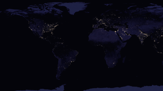


The team's latest set of night maps are clearer than ever, and reveal the "patterns of human settlement across our planet." The view of the Americas looks like an abstract painting by the late Jackson Pollack, with splashes of light from the Pacific coast, across the Sun Belt, through the Atlantic States, and around the Great Lakes. Scientists added clouds and sun glint "for aesthetic effect."
By the end of 2017, Roman's team will be able to provide the scientific community high-definition full-hemisphere views of Earth at night on a daily basis. The data will help in everything from forecasting the weather, to managing major disasters.
(Video: Courtesy NASA Goddard)
"Thanks to VIIRS, we can now monitor short-term changes caused by disturbances in power delivery, such as conflict, storms, earthquakes and brownouts," said Román. "We can monitor cyclical changes driven by reoccurring human activities such as holiday lighting and seasonal migrations. We can also monitor gradual changes driven by urbanization, out-migration, economic changes, and electrification. The fact that we can track all these different aspects at the heart of what defines a city is simply mind-boggling."
The accuracy of VIIRS data has already proven useful. It helped emergency responders track power outages during Hurricane Matthew last September. The United Nations is even using it to monitor the movement of displaced refugees in war-torn Syria.