Magnitude 4.3 Earthquake Strikes Off Central Coast
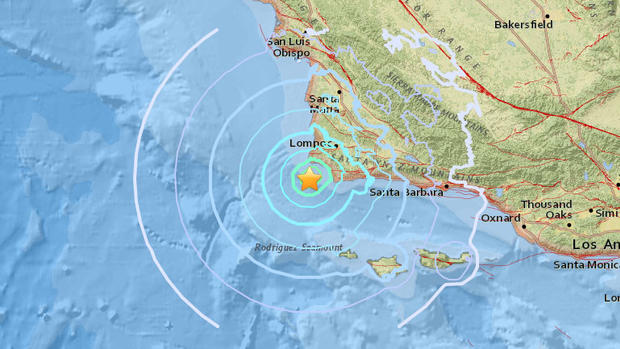
SANTA BARBARA (CBS SF) – A magnitude 4.3 earthquake struck off the coast of Santa Barbara County Thursday afternoon, according to the U.S. Geological Survey.
According to the USGS, the earthquake struck at 1:38 p.m. in the Pacific Ocean about 16 miles southwest of the town of Lompoc. The epicenter is about 53 miles west of Santa Barbara, 35 miles southwest of Santa Maria and more than 50 miles south of San Luis Obispo.
As of 2:00 p.m., visitors to the USGS website from as far away as Los Angeles County reported feeling the earthquake.
The National Tsunami Warning Center said a tsunami resulting from the earthquake is not expected.
COMPLETE QUAKE COVERAGE: CBS Earthquake Resource Center
This article will be updated as information warrants, and follow KPIX 5 on Twitter at @CBSSF or KCBS Radio on Twitter at @KCBSNews for updates on breaking news anytime.
DID YOU FEEL IT?: USGS Shake Map For Northern California
LIVE QUAKE MAP: Track Real-Time Hot Spots
BAY AREA FAULTS: Interactive Map Of Local Faults
Strong earthquakes with an epicenter off the coast can trigger tsunamis, depending on the size and type of the fault movement. The Pacific Tsunami Warning Center tracks earthquake data for the West Coast.
WEST COAST TSUNAMI TRACKING:
Tsunami Alerts & Maps