Magnitude 4.7 Earthquake Strikes Monterey County
SALINAS (CBS SF) -- A magnitude 4.7 earthquake that struck Monterey County late Monday morning was felt in parts of the Bay Area, according to the U.S. Geological Survey.
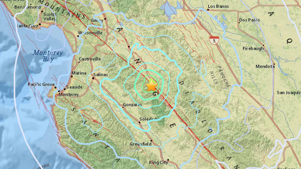
The earthquake struck at 11:31 a.m. about 22 miles east of Salinas and 14 miles northeast of the town of Gonzales, at a depth of about 3.8 miles.
Visitors to the USGS website from as far away as San Francisco, nearly 100 miles from the epicenter, reported feeling the earthquake.
The National Weather Service said a tsunami was not expected.
There are no immediate reports of damage or injuries.
COMPLETE QUAKE COVERAGE: CBS Earthquake Resource Center
This article will be updated as information warrants, and follow KPIX 5 on Twitter at @CBSSF or KCBS Radio on Twitter at @KCBSNews for updates on breaking news anytime.
DID YOU FEEL IT?: USGS Shake Map For Northern California
LIVE QUAKE MAP: Track Real-Time Hot Spots
BAY AREA FAULTS: Interactive Map Of Local Faults
Strong earthquakes with an epicenter off the coast can trigger tsunamis, depending on the size and type of the fault movement. The Pacific Tsunami Warning Center tracks earthquake data for the West Coast.
WEST COAST TSUNAMI TRACKING:
Tsunami Alerts & Maps