New Report Lists Wildfire Evacuation-Challenged Bay Area Cities
SAN FRANCISCO (CBS SF) -- When a wildfire strikes, as it did in the Oakland Hills in 1991 or in the devastation of Paradise last year, mere minutes can make the difference between a safe escape or a deadly outcome.
On Thursday, a new report was released warning Bay Area residents of the challenges they may face escaping a wildfire in their community.
During the Camp Fire in Paradise, fleeing residents were often constrained to a single two-lane road as the fire blazed behind them.
As wildfire season again approaches in California, a transportation analytics company's study aimed to identify the communities that'd be most affected so that focus could be zoned in on them to improve emergency escape planning.
The study by San Francisco-based Streetlight Data, Inc. used smartphone and GPS data to score 30,000 cities across the U.S. based on total population (only looking at those with populations under 40,000), the number of roadway exits leading outside and the average number of vehicles each route would carry on a typical day.
The study assumed that people would choose familiar and preferred routes to escape on in an emergency, even though other exits exist.
Of the 30,000 communities analyzed statewide, 22 in the Bay Area had scores that were three or more times the national average, signaling a dire concern for residents in these areas. Below is the ordered list (source: Streetlight Data):
- Santa Venetia
- Ladera
- Sleepy Hollow
- Bodega Bay
- Agua Caliente
- Yountville
- Marin City
- Sausalito
- Corte Madera
- San Anselmo
- St. Helena
- Fairfax
- Montara
- Pinole
- American Canyon
- Suisun City
- Cherryland
- Windsor
- Foster City
- Half Moon Bay
- San Lorenzo
- Pacifica
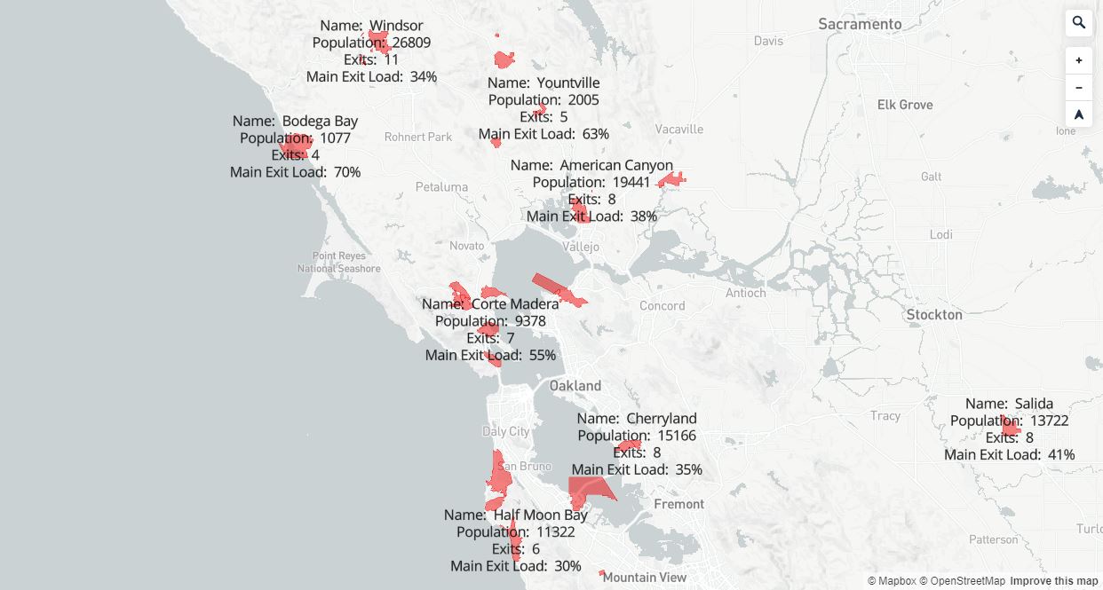
Streetlight Data's entire interactive map of the U.S. can be viewed here.
The findings show the towns in which residents would have the least options to flee in a rush, based on the percentage that many would clog the few main exits, labeled the main exit load percentage. Only 10 of the cities and towns of the list had populations over 10,000.
The top 10 on the list had populations under 10,000, main exit load percentages of over 55% and less than 10 total exits.
Streetlight Data CEO Laura Schewel told the East Bay Times that the study shouldn't be the defining guide on preparing for disasters, but county planners should use the data as a tool to refocus their efforts before an emergency strikes.
"Part of fire education might be reminding people they don't have to take the main exit during an emergency, and default behavior is not necessarily the right thing to do if you're moving a whole city," Schewel said.
"This data is not a robot that tells authorities what to do. But it is, we hope, a helpful tool in their toolbox," added Schewel.