'Firenado' Spotted As Hog Fire Scorches 8,000 Acres In Northern California
SUSANVILLE, Lassen County (CBS SF) – The Hog Fire burning in Northeastern California continued to burn overnight, tearing through thousands of acres and even creating its own weather.
According to Cal Fire, the fire burning west of Susanville in Lassen County has burned about 8,000 acres (12.5 square miles) and is 5 percent contained as of Tuesday morning. The agency previously estimated the fire's size to be more than 12,000 acres but was revised due to improved mapping.
"Receptive fuel beds are contributing to the fire intensity in spread," the agency said in an update posted Monday night. The fire has also damaged an essential fiber optic cable that impacted communications in Susanville and the incident command post for the fire.
In its Tuesday morning update, Cal Fire said the fire remained active overnight due to wind shifts, low fuel moisture and thunderstorms. "An increase in temperature and low humidity could support fire growth," officials warned. A red flag warning has been issued for the area.
No structures have been destroyed, but 170 structures are threatened. No injuries have been reported.
Photographer Josh Edelson said the fire became extremely erratic on Monday when a pyrocumulonimbus ash plume created its own weather. A fire tornado, also known as a "firewhirl" or "firenado" was spotted crossing Highway 36 near Susanville.
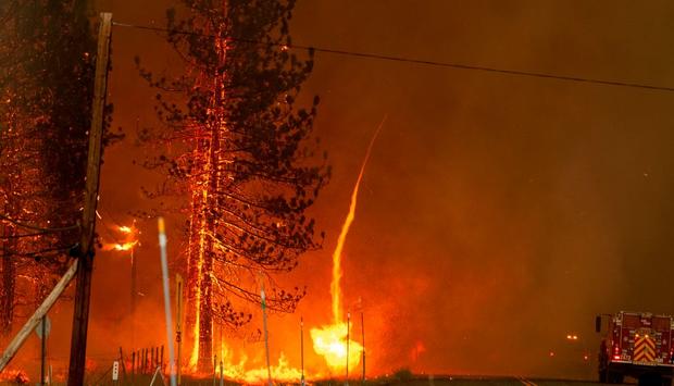
Fire tornadoes have occurred in previous California wildfires. During the Carr Fire that tore through Redding in 2018, the National Weather Service determined that a firewhirl packed winds topping 143 miles per hour, a wind speed equivalent to an EF 3 tornado on the Fujita scale.
Cal Fire said evacuation orders remain in effect for the community of Lake Forest Estates and along Highway 36 from County Road A1 to Willard Creed Road.
Smoke from the fire is leading to hazy skies over much of Northern California, along with the Reno and Lake Tahoe areas. The Bay Area Air Quality Management District has extended an air quality advisory for the region through at least Wednesday due to smoke from the Hog Fire and other wildfires burning in California.
More than 660 personnel have been assigned to battled the Hog Fire. Bay Area firefighters were set to join crews in Lassen County on Tuesday as engines from Alameda County, Contra Costa County, Palo Alto and San Ramon were deployed.
The cause of the Hog Fire is under investigation.