Deadly Nighttime Earthquake Strikes Philippines
MANILA, Philippines (CBS/AP) -- A powerful nighttime earthquake in the southern Philippines killed at least six people and injured more than 120, with officials combing through cracked buildings and nearby towns Saturday to check on the damage and other possible casualties.
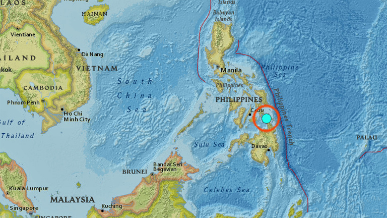
The magnitude 6.5 quake roused residents from their sleep late Friday in Surigao del Norte province, forcing hundreds of people to flee their homes. The quake was centered about 8 miles northwest of the provincial capital of Surigao at a relatively shallow depth of 6 miles, said Renato Solidum of the Philippine Institute of Seismology and Volcanology.
Nearly 100 aftershocks have been felt, officials said. Evacuation centers accommodated wary residents overnight, but many returned home Saturday, Welfare Secretary Judy Taguiwalo said, adding that officials were continuing to assess the damage in Surigao and outlying towns.
Provincial information officer Mary Jul Escalante was being interviewed by ABS-CBN TV network when another aftershock struck. "Oh sir, there's an aftershock," she said. "I'm shaking, we have a phobia now."
At least six people were killed, mostly after being struck by falling debris and concrete walls, provincial disaster-response official Gilbert Gonzales said.
In an earlier estimate, provincial disaster-response official Ramon Gotinga said at least 15 people had been killed, citing hospital reports.
At least 126 others were injured in Surigao, where the quake knocked out power and forced the closure of the domestic airport due to deep cracks in its runway, officials said.
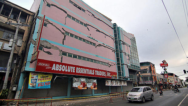
Several buildings, including a state college, a hotel and a shopping mall, were damaged in the city, located about 700 kilometers (430 miles) southeast of Manila. Surigao was placed under a state of calamity to allow faster release of emergency funds, provincial police chief Senior Superintendent Anthony Maghari said by phone.
TV footage showed army troops and other rescuers pulling out the body of a man from the concrete rubble of a damaged house while relatives wept. In Surigao's downtown area, the facade of a number of buildings were heavily cracked, their glass windows shattered with canopies and debris falling on parked cars on the street below.
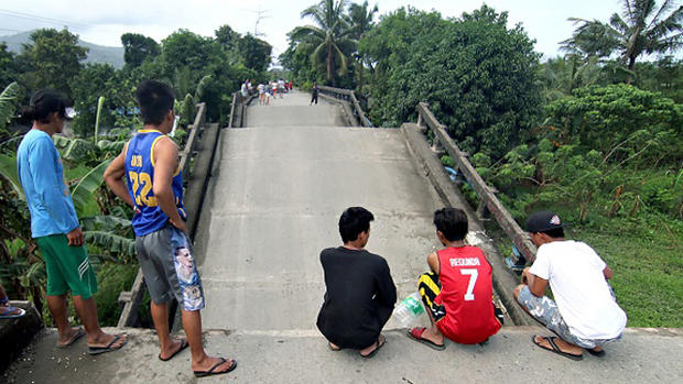
Roads had visible cracks in the coastal city and a bridge collapsed in an outlying town, officials said.
"The shaking was so strong I could hardly stand," coast guard personnel Rayner Neil Elopre said by phone.
Village leaders asked residents to move to a school building on higher ground, Elopre said, pausing briefly during a mild aftershock while talking on the phone.
Police officer Jimmy Sarael said he, his wife and two children embraced each other until the shaking eased. They later moved to the moonlit grounds outside the provincial capitol complex to join more than 1,000 jittery residents, he said.
The last major earthquake that struck Surigao, an impoverished region also dealing with a communist insurgency, was in the 1879, Solidum said. A magnitude 7.7 quake killed nearly 2,000 people on the northern island of Luzon in 1990.
Amid the calamity, the military appealed to New People's Army guerrillas not to disrupt rescue and rehabilitation work. "We urge you not to attack our soldiers," military spokesman Col. Edgard Arevalo said.
The Philippines sits in the Pacific "Ring of Fire," where earthquakes and volcanoes are common.
COMPLETE QUAKE COVERAGE: CBS Earthquake Resource Center
This article will be updated as information warrants, and follow KPIX 5 on Twitter at @CBSSF or KCBS Radio on Twitter at @KCBSNews for updates on breaking news anytime.
DID YOU FEEL IT?: USGS Shake Map For Northern California
LIVE QUAKE MAP: Track Real-Time Hot Spots
BAY AREA FAULTS: Interactive Map Of Local Faults
Strong earthquakes with an epicenter off the coast can trigger tsunamis, depending on the size and type of the fault movement. The Pacific Tsunami Warning Center tracks earthquake data for the West Coast.
WEST COAST TSUNAMI TRACKING:
TM and © Copyright 2017 CBS Radio Inc. and its relevant subsidiaries. CBS RADIO and EYE Logo TM and Copyright 2017 CBS Broadcasting Inc. Used under license. All Rights Reserved. This material may not be published, broadcast, rewritten, or redistributed. The Associated Press contributed to this report