LNU Lightning Complex Fires: 124,000 Acres, Nearly 200 Structures Burned; I-80 Reopens
VACAVILLE (CBS SF) -- Out-of-control wildfires touched off by lightning have torched more than 200 square miles and closed a major freeway in one of the major wildfires groups raging out of control in the Bay Area and Northern California.
The LNU Lightning Complex fires (map) which began in Napa and Sonoma counties, moved into Solano, Lake and Yolo counties Wednesday, prompting thousands of evacuations and closing Interstate 80 in Fairfield for more than four hours, as flames burned on both sides of the freeway.
- EVACUATIONS AND ROAD CLOSURES (updated 10 p.m.)
At least 124,100 acres - nearly 200 square miles - have burned since the fires began early Monday morning. Close to 200 different structures have been destroyed or damaged, and at least four people have been injured. There was zero percent containment as of 7 p.m. The group of fires are one of three major fire complexes burning in the region, along with the SCU Lightning Complex fires and the CZU Lightning Complex fires.
Flames on both sides of the freeway between Air Base Parkway and Cherry Glen Road in Fairfield led CHP to close all lanes of traffic eastbound and westbound at around 5 p.m. The closure was later expanded to between Manuel Campos Parkway and Cherry Glen Road. The sigalert was lifted around 9 p.m.
In Solano County, neighborhoods in Fairfield were evacuated Wednesday afternoon, ahead of flames that had already destroyed homes in Vacaville. On the northern edge of the fires in Lake County, evacuations were ordered for residents living in and around Hidden Valley Lake and Jerusalem Valley areas.
The commander at Travis Air Force Base issued a mandatory evacuation order at 7 p.m. Wednesday.
"The Travis Air Force Base installation commander has ordered evacuations for non-mission essential personnel in accordance with the Solano County fire department's mandatory evacuations," the statement read. "All non-mission essential personnel residing in Travis AFB housing or lodging are directed to evacuate immediately."
Driving along Pleasants Valley Road at the edge of Vacaville Wednesday afternoon, the damage from overnight becomes apparent quickly with mailboxes marking the spots where homes should be.
Not far beyond that, the danger that still remains becomes apparent as flames march down rugged hillsides toward more properties.
"My wife and my daughter and I were evacuated this morning," said area resident Sean Kerwin.
Kerwin wasn't just waiting for news. He and dozens of others were trying to rescue horses that had to be set loose from barns overnight as flames advanced.
"In this area, when it's a fire, it don't matter. Everybody's family at some point," said Keira Mackenzie.
On the other side of the sepia-tinted skies, new evacuation orders were sending residents fleeing. Dave Ritchey of Green Valley was there helping his mother and sister get out.
"This is our second time in two years. This fire...God, I get choked up. This fire is 10 times worse than the Atlas Peak fire," said Ritchey.
Just up the street, Jack Mackall had gone to the store before heading home to collect his wife and father in law.
"Get the heck out of Dodge," said Mackall
Ritchey also offered advice for anyone impacted by the fires.
If you get a warning, get out. If you feel it's not safe, get out. Because it's not, said Ritchey.
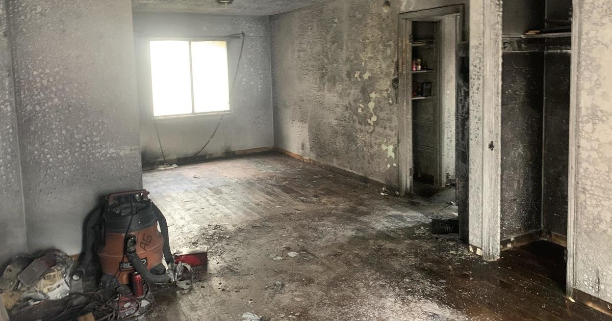
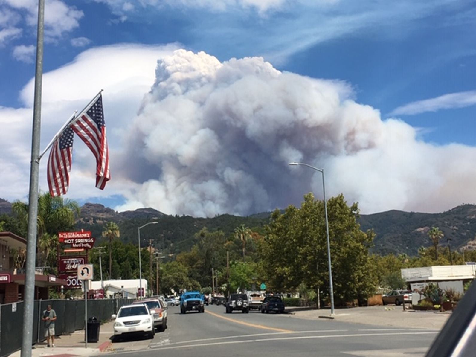
Wednesday morning, flames roared over Mt. Vaca in the early morning hours, knocking out a communication tower and then quickly moved toward I-80 and the neighborhoods nestled in northwest Vacaville. Along Pleasants Valley Road, multiple homes were burned to the ground in scenes reminiscent of the 2008 wildfire that destroyed the Butte County town of Paradise.
"The past 24 hours on the LNU Lightning Complex has been pretty dynamic with not only the fire growth but fire behavior we witnessed yesterday and also overnight into the early morning hours," said Cal Fire incident commander Sean Kavanaugh. "The fire weather not only in this region but throughout Northern California -- it's going to be a tough day. We have the hot dry winds that may occur this afternoon that may hamper some of our control efforts."
Kavanaugh warned people near the fires to be prepared even if no evacuation orders or warnings are issued in their area.
"You don't have to wait for an evacuation order," said Kavanaugh. "If you have a to-go bag, stuff packed up, if you feel at any type of threat whatsoever make that decision to leave your home,"
Cal Fire reported at least 50 homes had been destroyed and 50 others had been damaged, but the damage tally would rise. "We do anticipate that number to be larger," said spokesman Jeremy Rahn. "It would be safe to say there are multiple buildings that have been damaged or destroyed beyond that amount."
The largest of the LNU Complex fires, the Hennessey Fire that started near Hennessey Ridge Road in Napa County on Monday morning, had burned an estimated 12,500 acres and was not contained at all Wednesday morning, prompting evacuations that extended into areas near Vacaville in Solano County.
The Gamble Fire near Berryessa Knoxville Road had burned 13,000 acres and the Green Fire near Putah Creek Bridge and Berryessa Knoxville Road had burned about 8,000 acres, with both blazes also zero percent contained as of Wednesday morning, according to Cal Fire.
There were at least two other fires burning in Napa County with no containment -- the Markley Fire near Monticello Dam at 5,000 acres burned and the Morgan Fire at 2,200 acres burned.
In Sonoma County, about 10,000 people had evacuated from the Walbridge Fire west of Healdsburg that has burned about 1,500 acres, while the Myers Fire north of Jenner had burned 25 acres, both also with no containment.
In Vacaville, many local residents went to bed with the fire seemingly burning miles away. Then the winds kicked up and the fire quickly advanced on their homes, they were forced to flee with just the clothing they were wearing.
Police and firefighters were going door-to-door in a frantic scramble to make sure residents were able to escape the flames.
Among those scrambling to escape was a woman named Diane and her husband. She told KPIX 5 of her narrow escape.
"I got all my children out, but then I panicked a little bit. It took me a little while to get out," said Diane Bustos as she stood wearing a singed nightgown. "My husband was driving the car and it burned. He got burned and had to leave the car and it blew up. So I was walking down by myself and I got all these flames on me. I lost my shoes. But I made it, God saved me."
The fire blazed toward Pleasants Valley Rd & Pleasant Hills Ranch Way. Local resident Matthew Henderson went live on Facebook as he walked through a burning neighborhood -- several homes were fully engulfed in fire.
Residents of Pleasants Valley Road -- a 12-mile stretch which runs the length of Vacaville from Highway 128 to I-80 -- and all connecting streets scrambled from their homes as the fast-moving blaze -- one of several fires in the LNU Lightning Complex fire -- leaped over the roadway.
By 5:45 a.m., flames had roared into the Gibson Canyon and English Hills areas between Vacaville and Winters. At least two homes were destroyed by fires in the English Hills neighborhood. Firefighters had deployed south of Pleasants Valley Rd, ready to stop the flames from reaching further into Vacaville.
Related: Bay Area Wildfires
- CZU August Lightning Complex Fires: Roadways Jammed As Thousands Flee Out-Of-Control Santa Cruz Mountain Wildfires
- Fire Resources Spread Thin As Napa Wildfire Explodes In Size Forcing Mandatory Evacuations
- Firefighters Battling 700-Acre Fire In Point Reyes National Seashore; Evacuation Warning
- SCU Lightning Complex: Wind-Whipped Flames Straining Fire Lines; Residents Forced To Flee Homes
Kraig P. Kooiman took to social media to describe his sister's close call.
"My sister escaped without any warning that the fire was on their property," he posted. "Just drove through 30-foot flames escaped. Their property is at the end of Vickery Lane on the left side. There were last known there were two peoples trapped."
Brent Wolfe was among the Pleasants Valley Rd. evacuees.
"I actually got had a neighbor text me -- his house is gone and his father's house about that," he told KPIX 5. "The sheriff's department showed us and told us to vacate and if you have sprinklers turn them on and get out of here."
Meanwhile, the Vacaville Fire Department pleaded with residents to flee.
"All residents need to evacuate the West Side of Pleasants Valley Rd now," officials posted.
Evacuations orders were in place for all residents in Quail Canyon, Miller Canton, Mix Canyon, Gates Canyon, Pleasants Valley Rd and connecting streets/roads.
Elsewhere in Solano County, the Solano County Sheriff's Office said residents west of Blue Ridge Road to Interstate Highway 505 and
north of Cherry Glen Road to state Highway 128 were told evacuate immediately Wednesday morning.
The Fairfield Police Department issued advisories for the residential areas east of Interstate Highway 80 north of Manuel Campos Road;
residential areas west of Highway 80 off of Hilborn and Lyon roads; and residential areas near Rancho Solano Parkway.
Lake County
Evacuation Order:
Eastside of Highway 29 - North of the Napa/Lake County line up to the southern intersection of Highway 29/St. Helena Creek Road (Across from Twin Pine Casino)
All of St. Helena Creek Rd. - to the Highway 29/St. Helena Creek Road/Butts Canyon Intersection
Hidden Valley Lake and Jerusalem Valley areas, including residents living North of Butts Canyon Road, South of Hofacker Ln to Morgan Valley Rd, East of Hwy. 29 and West of the Lake/Napa County line.
A temporary evacuation point has been set up at the old airstrip off of Hwy. 53 in Clearlake.
Napa County
Evacuation Order:
- Community of Angwin
- Community of Deer Park
- St Helena Hospital
- East side of HWY 29 from Lake County line down to Silverado Trail
- East side of Silverado Trail from Highway 29 to Highway 128
- Northwest side of Highway 128 to Chiles Pope Valley Road
- Northwest side of Chiles Pope Valley Road to Pope Valley Road
- Northwest side of Pope Valley Road to Butts Canyon Road
- West side of Butts Canyon to Lake CountyHighway 128 from Lower Chiles Valley Road to Monticello Road
- Highway 128 from Chiles Pope Valley Road to Lower Chiles Valley Road
- Chiles Pope Valley Road from Highway 128 to Lower Chiles Valley Road
- All of Hennessey Ridge Road.
- From Moskowite Corner to Wooden Valley Rd, Including the community of Circle Oaks
- Atlas Peak from the Bubbing Well Pet Cemetary at 2462 Atlas Peak Rd to the dead end
- From Loma Vista Rd / Soda Canyon Rd to the dead end.
- All of Steele Canyon Rd from Hwy 128 to and including the Berryessa Highlands Sub Divison
- Wragg Canyon Rd - from Hwy 128 to the end of the road, including Pleasure Cove Resort
- Chiles Pope Valley Road - From Lower Chiles Valley Road to Pope Canyon Road
- Highway 121 (Monticello Road) – from Wooden Valley Road to Silveraldo Trail
- Pope Valley Rode – From Aetna Springs Road to Chiles Pope Valley Road
- Aetna Springs Road – From Pope Valley to the dead end
- Butts Canyon Road – From Aetna Springs Road to the Lake County Line
- James Creek Road – From Butts Canyon Road to the dead end
- Highway 121 (Monticello Road) – from Wooden Valley Road to Vichy Ave.
Evacuation Shelter at Crosswalk Community Church, 2590 First St., Napa
Solano County
Map of evacuation areas (link)
Evacuation Order
- Fairfield - Peabody Road, Vanden Road, Cement Hill Road.
Evacuation Warning
- Fairfield - Rancho Solano neighborhood
- Fairfield - Sanctuary neighborhood
Evacuation centers at Lambrecht Fields, Petersen Rd Suisun City, Rodriquez High School, Fairfield High School
Sonoma County
Evacuation Order:
- North of Austin Creek Recreational Area
- East of The Cedars
- Mill Creek Road west of the intersection of Puccioni Road
- South of Stewarts Point Skaggs Springs Road
- South of Stewarts Point Skaggs Springs Road
- West of West Dry Creek Road and Westside Road
- North of Sweetwater Springs Road and McCray Ridge Road
- East of the East Austin Creek (the actual creek)
- Ink Grade – from Pope Valley Road to White Cottage Road
- Howell Mountain Road – From Pope Valley Road to White Cottage Road
Evacuation Warning:
- All residents of the City of Healdsburg
- Monticello Road from Vichy Ave to Silverado Trail
- West of Meyers Grade Road to the coast
- South of Fort Ross Road
- North of Russian Gulch State Beach
- North of Austin Cree Recreational Area
- East of Cedars
- West of Mill Creek Rd
- South of Stewarts Point-Skaggs Spring Road
- Meyers Fire - County Evacuation Zone 1F1
All areas east of Bohemian Hwy.
North of Graton Rd. and Harrison Grade Rd.
West of Harrison Grade Rd., Green Valley Rd., and Hwy. 116
South of the Russian River - Meyers Fire - County Evacuation Zone 1F2
All areas south of the Russian River
East and North of Hwy. 116 (Pocket Canyon)
West of Martinelli Rd. - Walbridge Fire - County Evacuation Zone 4A1
All areas East of the Russian River
North of River Rd.
West of Trenton Healdsburg Rd. and Eastside Rd.
South of the area between the western dead end of Windsor River Rd. and
the Russian River - Walbridge – Evacuation Zone 4B1 (Northern Forestville)
All areas south of River Rd. from Martinelli Rd. to Trenton Rd.
West of Covey Rd.
North of Front St. / Hwy. 116
East of Martinelli Rd. - Walbridge – Evacuation Zone 2K2
All areas south of Hwy. 101
East of the Russian River to the Windsor Town limits
North of where Windsor River Rd. dead ends extending west to the Russian River. - Meyers – Evacuation Zone 1E3
All areas south of the Russian River
West of Bohemian Hwy.
North and East of Coleman valley Rd. and Willow Creek Rd. - Meyers – Evacuation Zone 1E1
All areas south and west of Willow Creek Rd.
North of Coleman Valley Rd. and Wright Hill Rd.
East of the California Coastal National Monument (BLM property) - Meyers - Evacuation Zone - 1C1
All areas east of the Sonoma coast to the south fork of the Gualala River.
South of Kruse Ranch Rd. and Howser Bridge Rd. to Fort Ross Rd.
Evacuation Shelter: Crosswalk Community Church, 2590 First St., Napa
Temporary evacuation points:
- A Place to Play, 2375 West 3rd St., Santa Rosa
- Schopflin Fields, 4351 Old Redwood Highway, Santa Rosa
- Vets Memorial Beach, 13839 Old Redwood Highway, Healdsburg
- Westside Park, 2400 Westshore Rd, Bodega Bay
- Ragle Ranch, 500 Ragle Rd, Sebastopol
Animal Evacuation Center:
Napa County Animal Shelter
942 Hartle Court
Napa, CA 94559
Road Closures:
Napa County:
- SR-121 at Wooden Valley Rd (this was previously the SR-121 at SR-128 closure). This closure will be staffed by an officer. Circle Oaks is being or will be evacuated
- SR-128 at Pleasent's Valley Rd. Woodland CHP and Caltrans are staffing this closure. No traffic westbound on SR-128 from this intersection. Traffic can move east on SR-128 and south on Pleasent's Valley Rd
- Butts Canyon Rd at Snell Valley Rd. This closure is staffed by a CHP officer. We do not want anyone traveling south on Butts Canyon Rd past this intersection
- SR-128 at Silverado Trail. This closure is staffed by a CHP officer and Caltrans
- Napa County Roads is working on the following closures:
- Atlas Peak Rd at Westgate Drive. No traffic north on Atlas Peak Rd. past Westgate Drive. This section of Atlas Peak is being or will be evacuated
- Soda Canyon Rd at Silverado Trail. Soda Canyon Rd. north of Loma Vista Drive is being or will be evacuated. We do not want any traffic on Soda Canyon Rd north of Loma Vista--it's easier to close it at Silverado Trail
Sonoma County:
- SR-1 @ Fort Ross Road- No traffic on S/B SR-1 and no traffic E/B on Fort Ross Rd
- SR-1 @ Meyers Grade Road- No traffic on N/B SR-1 and no traffic on N/B Meyers Grade Rd
- Fort Ross Road at Seaview Road- No traffic on W/B Fort Ross Rd. and no traffic on E/B Fort Ross Rd
- Myers Grade Road at Fort Ross Road- No traffic on S/B Meyers Grade Rd
- Dry Creek Rd at Dry Creek
- Yoaking Bridge Rd at Dry Creek
- Lyton Springs Rd at Dry Creek
- Westside Rd @ Dry Creek
- Wohler Rd at River Rd
- Odd Fellows Park Rd at Russian River
- Bohemian Hwy at Russian River
- Mosscow Rd at Hwy 116
- Hwy 116 at Hwy 1 (Move Hwy 1 at Myers Grade)
- King Ridge Rd @ Sewell Rd (private Rd with gates)
- Skaggs Spings Rd at Sewell Rd (Anvil Ranch)
Katie Nielsen and Andria Borba contributed to this story