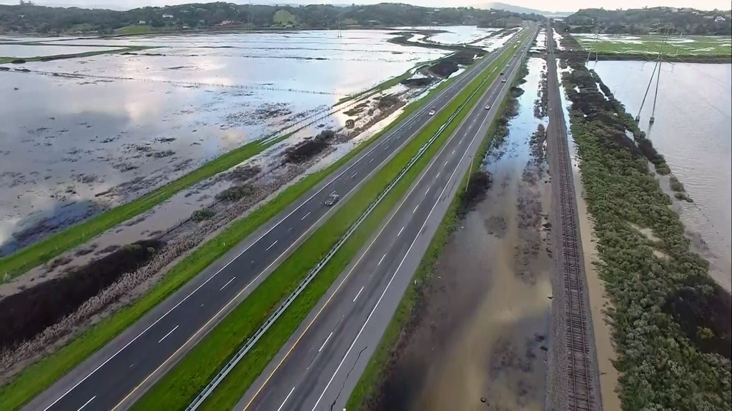
Caltrans Predicts Highway 37 To Be Permanently Flooded by Mid-Century; Seeks Solutions For Vital Corridor
SAN FRANCISCO (CBS SF) -- With San Francisco Bay Area sea levels expected to rise two to five feet by the end of the century, it's predicted that most of state Route 37 will likely become permanently inundated by the mid-century or as soon as 2040, according to the California Department of Transportation, thus cutting off a major regional transportation route.
Route 37 follows the northern shore of San Pablo Bay, and a large portion of the 21-mile roadway is lower than the surrounding levees, causing it to be frequently flooded and closed during particularly rainy winter months.
Caltrans is seeking public comment on its efforts to find solutions to this corridor's challenges while protecting and enhancing sensitive marshland habitats along the northern shore of San Pablo Bay.
A virtual public meeting is scheduled to be held at 5:30 p.m. Jan. 25 to provide an update on a study of the planning issues and to receive public input on proposed alignments to the route. For meeting details, visit the SR37 Project Meetings & Events page on the Caltrans District 4 SR 37 webpage online.
Caltrans says the route is "extremely vulnerable" to flood-related closures due to sea level rise, attributed to climate change, and it experiences a high level of traffic congestion. Caltrans, the Metropolitan Transportation Commission and the four North Bay Area counties are partners in the Resilient SR 37 program working on multiple studies addressing the corridor's issues.
Caltrans is preparing a comprehensive long-range study -- the Planning and Environmental Linkages Study -- to identify the best solutions. It's the first roadway in the state to follow this federal planning outline. Caltrans will identify transportation options, determine needs and consider alternatives within this critical corridor.
Caltrans says planning a long-term solution presents an opportunity to provide bicycle, pedestrian, transit and carpool options, as it aims to develop a more resilient corridor.
The public is invited to fill out this questionnaire: https://www.surveymonkey.com/r/GNC8PX9. To join the meeting on Jan. 25 use the link https://us02web.zoom.us/j/87256452910 (Password: 762806) or join by phone 1-877-853-5247 (Meeting ID: 872 5645 2910, Meeting Password: 762806)
Learn more about the Route 37 projects: https://dot.ca.gov/caltrans-near-me/district-4/d4-projects/d4-37-corridor-projects.
© Copyright 2022 CBS Broadcasting Inc. and Bay City News Service. All Rights Reserved. This material may not be published, broadcast, rewritten or redistributed.