Scientists Now Predicting Near 100% Chance Of Strong El Nino, But Rainfall Isn't Always Guaranteed
(CBS SF) -- Climate experts say El Nino is growing stronger and could bring drought-busting wet weather to California this year. While the ocean condition is nearly guaranteed, rainfall doesn't always follow the sea temperature increase.
On Thursday, scientists at the International Research Institute for Climate and Society (IRI) said chances for El Nino this summer are close to 100 percent, with simulations suggesting by December, it could exceed the devastating 1997-1998 event that brought widespread flooding and hurricane-force winds to most of California.
So far, the mean ocean temperatures are already above 2º Celsius. For Pacific Ocean temperatures, an anomaly in the range of 1.5 to 3.5 degrees Celsius would be considered characteristic of an El Nino. The warmer and more widespread the water, the stronger the El Nino.
In recent years, IRI scientists said global warming has made it difficult to predict an El Nino event, often leading forecasters astray.
Looking at the line models on the graph of temperatures over the next few months, it shows the vast majority of computers models predicting significant increases in ocean temperature, which usually indicate torrential rain. By the end of summer, only two models (shown in green and blue) predict the ocean cools back down. If the opposite outlier is accurate, temperatures in the ocean would soar well over 3 degrees, giving California a record-setting and likely disastrous El Nino.
What is known for certain is that for the next 3 months, every single computer model agrees on at least a 1 degree or higher El Nino continuing. By July, scientists will know what winter may look like.
ALSO READ:
East Bay Yellow Jacket Attacks May Be Drought-Related
Climate Change, Drought Likely Means Marijuana Grown In California Will Be More Potent
The ocean temperatures weren't as stark in 2014. Last spring, computer models predicted El Nino would deliver a good soaking to California. A month later, the westerly wind anomalies quit and the atmosphere stopped participating in the El Nino pattern. California ended up seeing the driest January in 40 years last winter as reservoir levels sank lower and the four-year drought lingered on.
But scientists say this most recent prediction is alarming since we are already starting with noticeably warmer ocean temperatures compared to the same time last year.
"The difference is that this year an El Nino is already in place, with both ocean and atmosphere participating in the coupled climate phenomenon," said IRI's Chief Forecaster Tony Barnston.
On top of that, the warm subsurface water has started discharging to the surface, which is key for the formation of an El Nino event.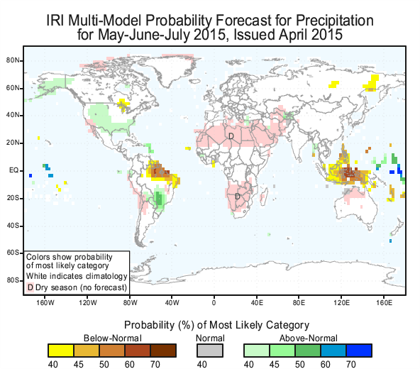
IRI scientists warn they're still in what they call the "spring predictability barrier" so things could easily change. The exact conditions coming this fall won't be known with certainty for another six weeks.
KPIX 5 meteorologist Roberta Gonzales agrees.
"Predicting a strong El Nino is certainly exciting and favorable, however, I strongly believe it's way too early to forecast such extreme weather."
But if the simulations were to continue in this trend, then California and most of the Northern Hemisphere is due for wet weather while Indonesia, northern Australia and South America, and Central America are likely to experience much drier conditions.