Evacuations Expand as Firefighters Battle Merged Dixie, Fly Fires Near Lake Almanor
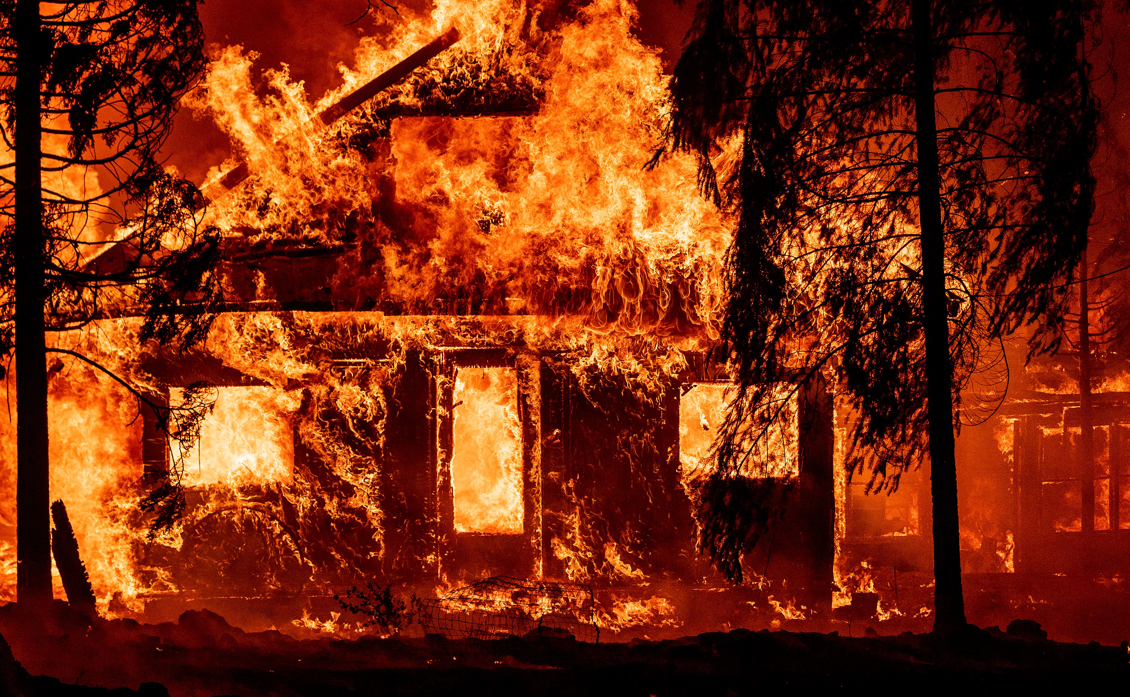
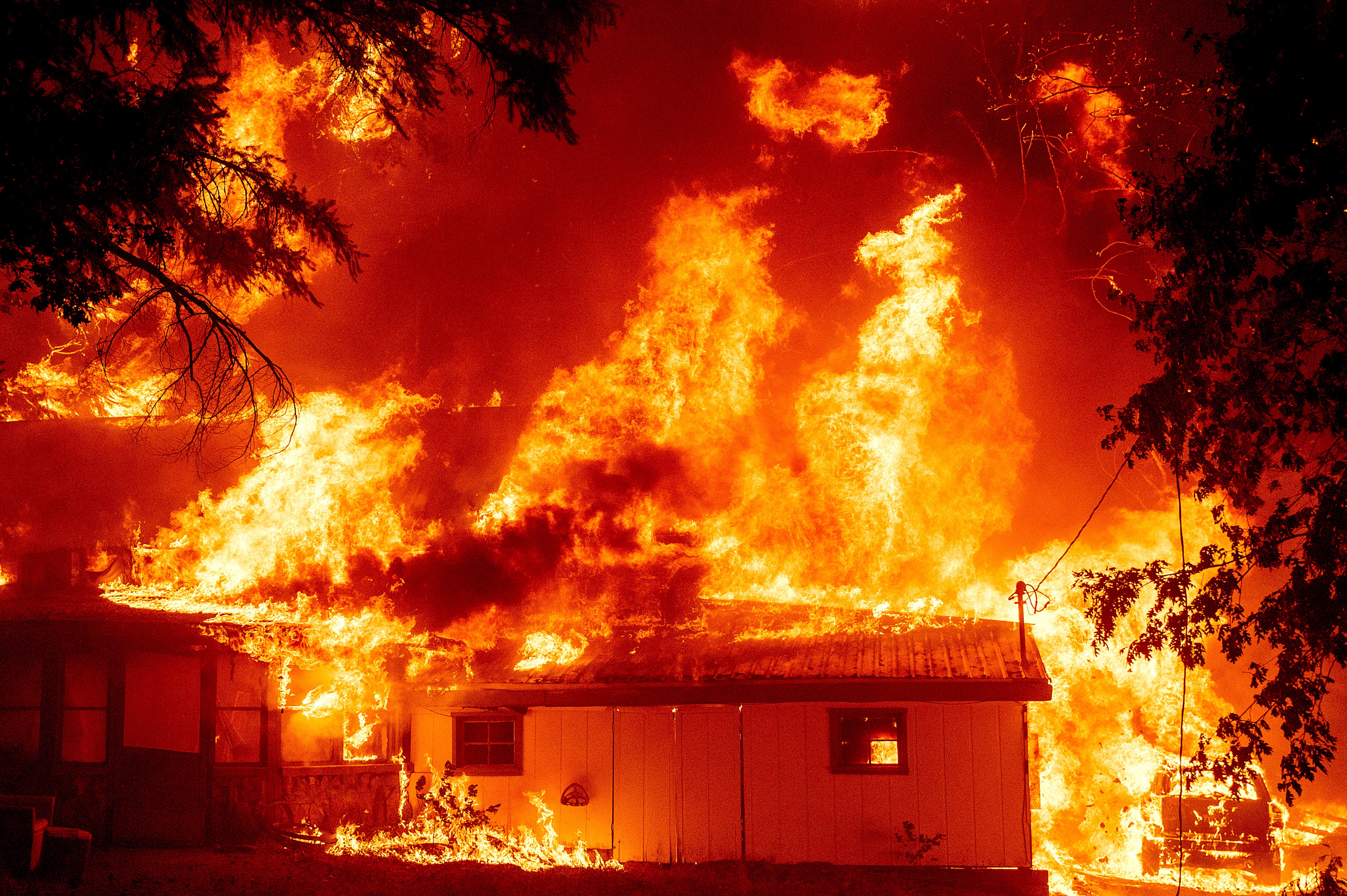
INDIAN FALLS (CBS SF) -- Fueled by tinder-dry, drought-stricken trees and brush, a wall of flames from the raging Dixie Fire roared through the Plumas County town of Indian Falls Saturday evening, leaving a destructive path of charred vehicles, burned homes and shattered dreams.
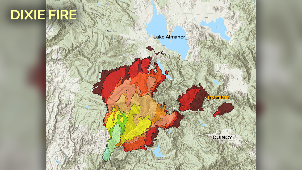
Overnight, the Dixie and Fly fires burning in Butte and Plumas counties merged, making up an estimated 192,849 acres combined.
The fire prompted evacuation orders in several small mountain communities and along the west shore of Lake Almanor, a popular resort area.
On Sunday, mandatory evacuation orders were issued for Genesee Valley North, East Indian Valley, Grizzly Mountain, the east shore of Highway 147 from Canyon Dam north to Highway 147 and A13 intersection east of Highway 147 at CO A13 to little Dyer Mountain southeast to Dyer Mountain.
According to the Placer County Sheriff's Office, mandatory evacuations were expanded Sunday afternoon to include the east shore of Lake Almanor, including Highway 147 from Canyon Dam north to the Highway 147 and County Road A-13 intersection, as well as east of Highway 147 at County Road A-13 to Little Dyer Mountain and southeast to Dyer Mountain.
Authorities advise evacuating to the north as an evacuation shelter was established at Lassen Community College in Susanville.
Additionally, as mandatory evacuation orders have expanded, evacuation warnings are now in place for the following areas: Moonlight Valley, Engel Mine, Lone Rock Valley, a Portion of Growers Boulevard, Kettle Rock, Taylor Lake, Wilcox Valley, Rattle Snake Peak, Franks Valley, Babcock Crossing, Elephants Playground, Murdock Crossing, Walker Mine, the west portion of Grizzly Valley, Mt. Ingalls, Greenhorn, Spring Garden and Massack.
While the images from Indian Falls were frightening, there were also victories as fire crews were able to save some structures from the blaze. Structures also burned in the rural community of Paxton.
Photo Gallery: Wall Of Flames Burns Homes In Indian Falls
The Dixie fire, which started July 14, was burning in a remote area with limited access.
Firefighters carrying hand tools were forced to hike through rugged terrain where engines can't go, said Rick Carhart, spokesman for the California Department of Forestry and Fire Protection.
"It has been burning in extremely steep canyons, some places where it is almost impossible for human beings to set foot on the ground to get in there," he said. "It's going to be a long haul."
Still, crews made progress Saturday by proactively setting fires to rob the main blaze of fuels, Carhart said.
The wildfire has marched eastward with such intensity and speed it has forced firefighters to retreat to safe refuges.
"The threats and risks associated with this fire are very real," said Cal Incident Team 2 commander Mike Minton. "We are observing fire behavior, conditions and fuel conditions that are not common for this area. The rapid rates of fire growth we are seeing are very real -- We experienced that today in the Greenville 'Y'. It's very extreme fire behavior that essentially caused firefighters to have to retreat into safe areas and allow for that fire front to make its passage."
Other communities including Taylorsville, Greenville, Twain, Crescent Mills and homes in the Butterfly Valley were also being threatened by the fire's eastward march.
Among those driven from their homes by the fire is Kylie Ojers, who is hoping the flames will spare her house.
"We were evacuated Monday," she said. "It was more than 20 miles away and now it's within four miles of our house...It's going right in the direction of our house."
William Helt was also forced from his home.
"It was raining ash, it was just dark skies, everyone kind of had this worried ominous feeling, you know, it was, you could tell there was panic," he said of his exodus from the fire zone. "I just hoped there's a house to go back to."
During a Saturday night update on the fire, Plumas County Sheriff Todd Johns begged local residents to heed the call to evacuate.
"The fire is now at the top of the ridge (near Taylorsville)," he said pointing to Saturday's rapid eastern growth on the map. "You know how steep the mountains are behind you. If you have not done so, I highly encourage you to evacuate if you live on Arlington Road in Taylorsville. The fire activity at this point has been crazy. It's extreme, most of the time it has been unpredictable."
"I'm asking the people who live in Taylorsville and wanting to stay there to reconsider that and leave the area."
As of Sunday afternoon, the blaze remained 21% contained.
There were 5,022 firefighters engaged in the battle and 10,721 structures were threatened.
The weather forecast for Sunday included a chance of lightning and intense short downpours. Those gusty conditions will also whip up extreme wind behavior along the fire front.
"I wish I had better news," said Cal Fire meteorologist Julia Ruthford Saturday night. "I know this is a pretty dire weather forecast. But it's what we got coming up."
DIXIE FIRE:
- Cal Fire Incident Report, Evacuation Information, Road Closures
- Butte, Plumas County Evacuation Map
- Butte County Website | Plumas County Website
© Copyright 2021 CBS Broadcasting Inc. All Rights Reserved. This material may not be published, broadcast, rewritten, or redistributed. The Associated Press contributed to this report