Early Morning Magnitude 3.8 Earthquake Strikes Near Hollister
HOLLISTER (KPIX 5) -- A magnitude 3.8 earthquake struck San Benito County early Friday morning, according to the U.S. Geological Survey.
The USGS reports the earthquake struck at 6:29 a.m. near the community of Tres Pinos, about 6 miles south of Hollister.
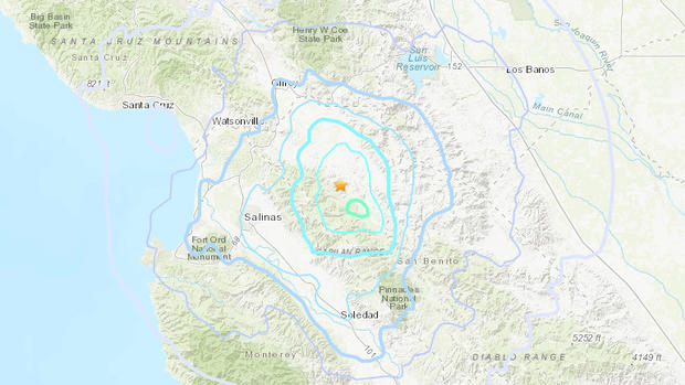
While the quake was mostly felt in the Santa Cruz, Monterey and Salinas areas, visitors to the USGS website from as far away as the South Bay and Peninsula said they felt the shaking.
There are no immediate reports of damage or injuries.
COMPLETE QUAKE COVERAGE: CBS San Francisco Earthquake Resource Center
This article will be updated as information warrants, and follow KPIX 5 on Twitter at @KPIXtv for updates on breaking news anytime.
DID YOU FEEL IT?: USGS Shake Map For Northern California
LIVE QUAKE MAP: Track Real-Time Hot Spots
BAY AREA FAULTS: Interactive Map Of Local Faults
Strong earthquakes with an epicenter off the coast can trigger tsunamis, depending on the size and type of the fault movement. The Pacific Tsunami Warning Center tracks earthquake data for the West Coast.
WEST COAST TSUNAMI TRACKING:
Tsunami Alerts & Maps