LNU Lightning Complex: Shifting Wind Pushes Walbridge Fire Toward North Bay Communities
HEALDSBURG (KPIX) -- This was a day of significant changes for the Walbridge Fire. Winds shifted, evacuation areas grew and new concerns emerged.
"For the last several days we've been working with winds pushing out of the north, northwest to the south, southeast," said Paul Lowenathal of Cal Fire. "That's why a lot of warnings have been in place for the Russian River community. The wind is now going to come out of the south-southwest and push to the north-northeast ... concern focuses on the side of the fire so that's gonna be everything from the west side of 101 from up around Geyserville down through Healdsburg."
Up and down the west side of Highway 101, this was another day for residents to learn their evacuation zone.
"We're just hoping we can get through the next three days and will come out OK on the other side," said Jesse Sherman as he and his family packed their cars on the western edge of Healdsburg.
These areas had been under an evacuation warning for days. Now it was time to clear out with the anticipation that firefighters would be coming in.
"So, our main concern is for them and their safety -- to get out of their way so they can do their job," Sherman said.
Cal Fire has been laying the groundwork for the job. Over the past two days they have delivered a heavy air attack, complete with the Super Tanker, in the areas northwest of Healdsburg and west of Geyserville.
"Essentially that airshow that's been taking place on the north side of the fire, bulldozers cutting lines, it has essentially been preparing for this," Lowenathal explained.
What is harder to prepare for is the approaching weather and the possibility of more dry lightning.
"So the struggle now is 'where is the system going to move through exactly?'" Lowenathal said. "Not only the lightning but the weather conditions that come with those thunderstorms. So you've got downdrafts, the winds on the front end of the system -- in the back of the system. All of those are potentially going to play into how we operate and what our priorities are over the next several days."
EVACUATIONS AND ROAD CLOSURES
EVACUATION ORDER(S)LIFTED - Yolo County
WHAT: Evacuation Orders(s) Lifted: The formal announcement of lifting evacuations in an area currently under evacuation.
WHEN: IMMEDIATELY
WHERE:All areas of Yolo County, within Evacuation Zones 2,8,9,15,31,46,55, and 60
- Fire personnel are still active in the area. Please reduce speeds and drive with caution. Access will be limited to residents only; no other public access will be granted at this time.
- The cancellation of additional evacuation orders is being evaluated based on a variety of factors, including potential fire behavior, and the re-establishment of crucial infrastructure.
LNU LIGHTNING COMPLEX EVACUATION UPDATE – Lake County 8/22/20 6PM
WHEN: IMMEDIATELY
EVACUATION WARNING:
The Lake County Sheriff's Office has issued additional EVACUATION WARNINGS for the following areas:
- All residences and areas east of SR-29, north of Morgan Valley Rd., south of SR-20, west of the previous warning evacuation line (08/21/20)(Sky High Ridge Rd., from Morgan Valley Rd. extending north to SR-20,) not to include any residents within the city limits of Clearlake.
- All residences along and east of Big Canyon Rd., Perini Rd., and Seigler Canyon Rd., South of SR-29, west of SR-29, and north of the warning line (08/21/20)(Anderson Springs Rd., Neft Rd., and Boggs Mt Rec Area extending northeast to the intersection of SR-29 / Hofacker Rd.)
We are asking everyone to take preparations in the event that an Evacuation Order is issued. Preparations should include gathering all medications, important documents, making plans for pets, and notifying family members where you may be going. Those requiring additional time to evacuate or those with pets or livestock should leave the area as soon as possible. During a mandatory evacuation, it will be extremely hectic and traffic conditions will be very congested. By evacuating early, you do your part in keeping yourself, your neighbors, and our first responders safe. Should an evacuation order be issued and shelter is needed, you will be directed to a Temporary Evacuation Point (TEP).
NOTES: SAFETY MESSAGE – The public is reminded to stay vigilant on current fire conditions. Please continue to adhere to road closures and any evacuation warnings. A reminder to drive slowly and yield to emergency personnel in the area. There will be smoke in the respective areas as firefighters continue firefighting operations. If at any time you feel unsafe, please call 911.
YOLO COUNTY LNU LIGHTNING FIRE COMPLEX COMMUNITY BRIEFING
Streamed from the Yache Dehe Fire Department (no in-person attendance)
Date: Sunday, August 23, 2020
Time: 2:30PM
Location:
- https://www.facebook.com/YoloCounty/
- https://www.facebook.com/yochadehewn/
- https://www.facebook.com/YochaDeheFD/
LNU LIGHTNING COMPLEX EVACUATION UPDATE – Lake County
WHAT: Evacuation Order: Immediate threat to life. This is a lawful order to leave now. The area is lawfully closed to public access.
WHEN: IMMEDIATELY
EVACUATION ORDER:
- The Lake County Sheriff's Office has issued an EVACUATION ORDER for residents living in the following areas: All residents living south of Morgan Valley Rd., west of the Mandatory Evacuation boarder line at Sky High Ridge Rd. to HWY 29 and HWY 53 in Lower Lake. East of HWY 29 at Hofacker Ln. to the Mandatory Evacuation Boarder line. This area was previously under a warning and has been upgraded to an order.NOTES: SAFETY MESSAGE – The public is reminded to stay vigilant on current fire conditions. Please continue to adhere to road closures and any evacuation warnings. A reminder to drive slowly and yield to emergency personnel in the area. There will be smoke in the respective areas as firefighters continue firefighting operations. If at any time you feel unsafe, please call 911.
Residents may experience very smokey conditions as the firefight continues. Smokey conditions can be unhealthful to many people especially children, the elderly, and anyone with respiratory problems.
LNU LIGHTNING COMPLEX EVACUATION ORDERS LIFTED - NAPA COUNTY
WHAT:
Evacuation Orders(s) Lifted: The formal announcement of lifting evacuations in an area currently under evacuation.
WHEN:
Effective Immediately
WHERE:
- The Evacuation Warning along Highway 121 (Monticello Road) from Vichy Ave to Silverado Trail is lifted and no longer in place.
- All other Evacuation Orders and road closures remain in place.NOTES: Fire personnel are still active in the area. Please reduce speeds and drive with caution. Access will be limited to residents only; no other public access will be granted at this time. The cancellation of additional evacuation orders is being evaluated based on a variety of factors, including potential fire behavior, and the re-establishment of crucial infrastructure.
For additional information on returning home after a wildfire, go to: here communications/downloads/fact_sheets/PGE_ReturningHomeAfterAfterAFire_print.pdf
LNU LIGHTNING COMPLEX EVACUATION UPDATE - SONOMA COUNTY
WHAT:
- Evacuation Order: Immediate threat to life. This is a lawful order to leave now. The area is lawfully closed to public access.
- Evacuation Warning: Potential threat to life and/or property. Those who require additional time to evacuate, and those with pets and livestock should leave now.WHEN: IMMEDIATELY
EVACUATION ORDER:
- ZONE 2F1East of Dutcher Creek Road and the Dry Creek (the actual creek)
North of Canyon Road
West of Hwy 101
ZONE 2F2
South of Canyon Road
East of the Dry Creek (the actual creek)
North of Lytton Springs Road
West of Geyserville Avenue
ZONE 2F3
South of Lytton Springs Road
East of the Dry Creek (the actual creek)
North of Westside Road
West of the Healdsburg city limits.
ZONE 2K1
All areas North and East of Westside Rd.
West of Hwy. 101
West of the Russian River
ZONE 2K2
All areas west of Hwy. 101
East of the Russian River to the Windsor Town limits
North of where Windsor River Rd. dead ends extending west to the Russian River
ZONE 4A1
All areas East of the Russian River
North of River Rd.
West of Trenton Healdsburg Rd. and Eastside Rd.
South of the area between the western dead end of Windsor River Rd. and the Russian River
ZONE 4C1
North of Guerneville Road
East of Covey Road and Hwy 116
West of Laguna Rd
South of River Road
CITY OF HEALDBURG
The residents in the City of Healdsburg West of Highway 101 off of Chiquita Road are under an Evacuation Order. This includes Chateau Real, Matteri Rd, Burgundy Rd, Chablis Rd, Zinfandel Rd, and Riesling Rd. All areas in the city of Healdsburg East of Highway 101 remain on an Evacuation Warning.
EVACUATION WARNING:
ZONE 4A2
East of Trenton Healdsburd Road
North of Mark West Station Road
West of the Windsor City Limits and Windsor Road
South of Windsor River Road
ZONE 4A3
East of Trenton Healdsburg Road
North of River Road
West of Slusser Road
South of Mark West Station Road
ZONE 2A2
North of the Dry Creek and the norther fork of Lak Sonoma County
West of Dutcher Creek, City of Coverdale city limits and Hwy 128
South of the Mendocino County line
ZONE 2C4
South and West of Asti Road
East of Hwy 101
North of Hwy 128
ZONE 2G1
East of Hwy 101
South and West of Hwy 128
North of Alexander Valley Road
Town of Windsor Zone A
North of Windsor River Road
West of Hwy 101
All to the Western and norther town limits west of 101ZONE 2G1
LNU LIGHTNING COMPLEX FIRE PRESS CONFERENCE ANNOUNCEMENT
WHAT: LNU Lightning Complex, will provide an update on the current status of the fires and will be available to answer questions after the press conference
WHEN: 11:00 a.m. today August 22, 2020
WHERE: Napa County Fairgrounds 1435 North Oak Street Calistoga, CA 94515
NOTE: Live streaming of the press conference will be available on Facebook by following @CALFIRELNU.
LNU LIGHTNING COMPLEX INCIDENT UPDATE
Significant fire growth is expected throughout the rest of the operational period. Extreme fire behavior with short and long range spotting are continuing to challenge firefighting efforts. Fires continue to make runs in multiple directions and impacting multiple communities. Multiple fires have merged on the north side of Lake Berryessa into the Hennessey Fire, and continue to actively burn with critical spreads and is moving into large areas of timber.
Napa County and Lake County:
- Hennessey Fire (Merged Fires - Gamble, Green, Aetna, Markley, Spanish, Morgan, Round): Hennessey Ridge Road in Napa County, Califonia. The fire is current 261,793 acres and 15% containedSonoma County:
- Walbridge Fire (merged with Stewarts): West of Healdsburg. The fire is currently 50,069 acres and 0% contained
- Meyers Fire: North of Jenner. The fire is currently 2,345 acres and 0% contained
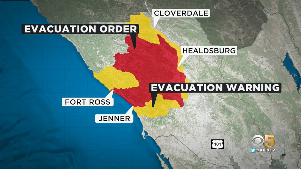
Sonoma County Fire Evacuation Map
Evacuations:
Napa County:
OES Info: https://www.countyofnapa.org/353/Emergency-Services
Evac Info: https://www.countyofnapa.org/CivicAlerts.aspx?AID=182
Napa County Information Line: (707) 253-4540
Evacuation Order:
- Highway 128 from Lower Chiles Valley Road to Monticello Road
- Highway 128 from Chiles Pope Valley Road to Lower Chiles Valley Road
- Chiles Pope Valley Road from Highway 128 to Lower Chiles Valley Road
- All of Hennessey Ridge Road.
- From Moskowite Corner to Wooden Valley Rd, Including the community of Circle Oaks
- Atlas Peak from the Bubbing Well Pet Cemetary at 2462 Atlas Peak Rd to the dead end
- From Loma Vista Rd / Soda Canyon Rd to the dead end.
- All of Steele Canyon Rd from Hwy 128 to and including the Berryessa Highlands Sub Divison
- Wragg Canyon Rd - from Hwy 128 to the end of the road, including Pleasure Cove Resort
- Chiles Pope Valley Road - From Lower Chiles Valley Road to Pope Canyon Road
- Highway 121 (Monticello Road) – from Wooden Valley Road to Silveraldo Trail
- Pope Valley Road – From Aetna Springs Road to Chiles Pope Valley Road
- Aetna Springs Road – From Pope Valley to the dead end
- Butts Canyon Road – From Aetna Springs Road to the Lake County Line
- James Creek Road – From Butts Canyon Road to the dead end
- Ink Grade – from Pope Valley Rd to White Cottage Rd
- Howell Mountain Rd – From Pope Valley Rd to White Cottage Rd
- Highway 121 (Monticello Road) – from Wooden Valley Road to Vichy Ave.
- Community of Angwin
- Community of Deer Park
- St Helena Hospital
- East side of HWY 29 from Lake County line down to Silverado Trail
- East side of Silverado Trail from Highway 29 to Highway 128
- Northwest side of Highway 128 to Chiles Pope Valley Road
- Northwest side of Chiles Pope Valley Road to Pope Valley Road
- Northwest side of Pope Valley Road to Butts Canyon Road
- West side of Butts Canyon to Lake County
Evacuation Lifted:
Evacuation Orders have been lifted and are no longer in effect for the portion of Silverado Trail between Rosedale Road and Highway 29. Evacuation Orders on Highway 29 from Silverado Trail to the Lake County Line, excluding the portion within the Calistoga City Limits, remain in effect.
Sonoma County:
Residents and visitors can dial 2-1-1
You can also view an interactive evacuation map at . https://arcg.is/0buuL1
Livestock 707-234-7193.
Evacuation Order:
- North of Austin Creek Recreational Area
- East of The Cedars
- Mill Creek Road west of the intersection of Puccioni Road
- South of Stewarts Point Skaggs Springs Road
- South of Stewarts Point Skaggs Springs Road
- West of West Dry Creek Road and Westside Road
- North of Sweetwater Springs Road and McCray Ridge Road
- East of the East Austin Creek (the actual creek)
Evacuation Warning:
- West of Meyers Grade Road to the coast
- South of Fort Ross Road
- North of Russian Gulch State Beach
- North of Austin Cree Recreational Area
- East of Cedars
- West of Mill Creek Rd
- South of Stewarts Point-Skaggs Spring Road
Meyers Fire - County Evacuation Zone 1F1
- All areas east of Bohemian Hwy.
- North of Graton Rd. and Harrison Grade Rd.
- West of Harrison Grade Rd., Green Valley Rd., and Hwy. 116
- South of the Russian RiverMeyers Fire - County Evacuation Zone 1F2
- All areas south of the Russian River
- East and North of Hwy. 116 (Pocket Canyon)
- West of Martinelli Rd
Walbridge Fire - County Evacuation Zone 4A1
- All areas East of the Russian River
- North of River Rd.
- West of Trenton Healdsburg Rd. and Eastside Rd.
- South of the area between the western dead end of Windsor River Rd. and the Russian River
Walbridge – Evacuation Zone 4B1 (Northern Forestville)
- All areas south of River Rd. from Martinelli Rd. to Trenton Rd.
- West of Covey Rd.
- North of Front St. / Hwy. 116
- East of Martinelli Rd.
Walbridge – Evacuation Zone 2K2
- All areas south of Hwy. 101
- East of the Russian River to the Windsor Town limits
- North of where Windsor River Rd. dead ends extending west to the Russian River.
Meyers – Evacuation Zone 1E3
- All areas south of the Russian River
- West of Bohemian Hwy.
- North and East of Coleman valley Rd. and Willow Creek Rd.
Meyers – Evacuation Zone 1E1
- All areas south and west of Willow Creek Rd.
- North of Coleman Valley Rd. and Wright Hill Rd.
- East of the California Coastal National Monument (BLM property)
Meyers - Evacuation Zone - 1C1
- All areas east of the Sonoma coast to the south fork of the Gualala River. South of Kruse Ranch Rd. and Howser Bridge Rd. to Fort Ross Rd.
Grid 2A3
- North of Stewarts Point Skaggs Springs Road to the eastern edge of Lake Sonoma
Everything west of the eastern edge of Lake Sonoma to the western boundary that runs north along the ridge line from the intersection of Stewarts Point Skaggs Springs Rd @ Old Stewarts Point Skaggs Springs Road to the interception of Rockpile Road @ Cooley Ranch Road north to the Mendocino County Line
Grid 4B1
All areas south of River Rd. from Martinelli Rd. to the intersection of River Rd at Trenton Rd. West of Covey Rd. North of Front St. / Hwy. 116 East of Martinelli Rd.
Lake County:
https://www.facebook.com/lakesheriff/
Evacuation Map:HERE
OES Contact:
(707) 262-4090
Sign Up for Lake County Alerts:
https://member.everbridge.net/index/892807736729003#/signup
Evacuation Order:
The Lake County Sheriff's Office has issued an EVACUATION ORDER for residents living in and around Hidden Valley Lake and Jerusalem Valley areas of Lake County due to a Wildland Fire. This includes residents living North of Butts Canyon Rd, South of Hofacker Ln to Morgan Valley Rd, East of Hwy. 29 and West of the Lake/Napa County line. Residents are advised that there is an IMMEDIATE threat to life and property from a wildfire, and are urged to evacuate. Please leave the area. If you are in need of shelter please proceed to a Temporary Evacuation Point (TEP) that has been setup at the old airstrip off of Hwy 53 in Clearlake. You are asked to stay in your vehicle and wear masks when you arrive at the TEP. A shelter is being established and you will be directed to the shelter by staff at the TEP.
- Eastside of Highway 29 – North of the Napa/Lake County line up to the Southern Intersection of Highway 29 / St Helena Creek Road (Across from the Twin Pine Casino)
- All of St Helena Creek Road - to the Highway 29 / St Helena Creek Road / Butts Canyon Intersection
- All areas and residents North and South of Morgan Valley Road (north of the previously established evacuation line (08/19/20) (from SR-29 and Hofacker Lane to Morgan Valley Road)
- East of Sky High Ridge Road (extending north to SR-20), South of SR-20, and West of the Lake County line
- Evacuation Warning:
- All areas west of Highway 29 (including areas west of Saint Helena creek Rd.)
- North and East of the Lake/Napa County Line (extending north to the Anderson Springs Rd. continuing between the County Line and Highway 175)
- South of Anderson Springs Rd, Neft Rd., and the Boggs Mountain Demonstration State Park
- Area prolongation to the intersection of Hofacker Ln. and SR-29
- This includes Middletown proper
- All areas and residents along Morgan Valley Road between Rocky Creek Road and Reiff Road
- Additional evacuations are ongoing, more to follow
Evacuation Center:
Napa County:
Crosswalk Community Church
2590 First Street
Napa, CA 94558
Sonoma County:
Santa Rosa Fair Grounds
1350 Bennett Valley Road
Santa Rosa, CA 95404
Lake County:
Temporary Evacuation Points: Is setup at the old airstrip off of Hwy 53 in Clearlake
Solano County:
- All Evacuation Centers in Solano County will be closing at 7:00 p.m. tonight
- Animal Evacuation Center:
Napa County Animal Shelter
942 Hartle Court
Napa, CA 94559
Solano County
- Vallejo Fairgrounds, 900 Fairgrounds Drive, Vallejo (large animals, current count 211 animals)
- Solano County Animal Shelter, 2510 Claybank Rd (small animals only, current count 285 animals)
Road Closures:
Napa County:
- SR-121 at Wooden Valley Rd (this was previously the SR-121 at SR-128 closure). This closure will be staffed by an officer. Circle Oaks is being or will be evacuated
- SR-128 at Pleasent's Valley Rd. Woodland CHP and Caltrans are staffing this closure. No traffic westbound on SR-128 from this intersection. Traffic can move east on SR-128 and south on Pleasent's Valley Rd
- Butts Canyon Rd at Snell Valley Rd. This closure is staffed by a CHP officer. We do not want anyone traveling south on Butts Canyon Rd past this intersection
- SR-128 at Silverado Trail. This closure is staffed by a CHP officer and Caltrans
- Napa County Roads is working on the following closures:
- Atlas Peak Rd at Westgate Drive. No traffic north on Atlas Peak Rd. past Westgate Drive. This section of Atlas Peak is being or will be evacuated
- Soda Canyon Rd at Silverado Trail. Soda Canyon Rd. north of Loma Vista Drive is being or will be evacuated. We do not want any traffic on Soda Canyon Rd north of Loma Vista--it's easier to close it at Silverado Trail
Sonoma County:
- SR-1 @ Fort Ross Road- No traffic on S/B SR-1 and no traffic E/B on Fort Ross Rd
- SR-1 @ Meyers Grade Road- No traffic on N/B SR-1 and no traffic on N/B Meyers Grade Rd
- Fort Ross Road at Seaview Road- No traffic on W/B Fort Ross Rd. and no traffic on E/B Fort Ross Rd
- Myers Grade Road at Fort Ross Road- No traffic on S/B Meyers Grade Rd
- Dry Creek Rd at Dry Creek
- Yoaking Bridge Rd at Dry Creek
- Lyton Springs Rd at Dry Creek
- Westside Rd @ Dry Creek
- Wohler Rd at River Rd
- Odd Fellows Park Rd at Russian River
- Bohemian Hwy at Russian River
- Mosscow Rd at Hwy 116
- Hwy 116 at Hwy 1 (Move Hwy 1 at Myers Grade)
- King Ridge Rd @ Sewell Rd (private Rd with gates)
- Skaggs Spings Rd at Sewell Rd (Anvil Ranch)
Solano County
- Auburn Road at Foothill Road
- Brown's Valley at Shelton
- Putah Creek Road at Winters Road
- Putah Creek Road at Winters Road
- Cherry Glen Road at Lyon Road
- Mankas Corner Road at Rancho Solano Parkway
- Suisun Valley Road at Rockville Road
- Abaernathy Rd. N/ Rockville Road
- N. Orchard Avenue at Vaca Valley Road
- Pleasants Valley @ SR-128
- Gibson Canyon Road at Fruitvale Road
- Cherry Glen Road at Pleasants Valley Road
- Timm Road at Peaceful Glen Road
- Gibson Canyon Road at Farrell Road
- Rollingwood Drive at Lyon Road
- Suisun Valley Road at Lambert Road
- Browns Valley Road at Cantelow Road
- Rice Lane north of Aldridge Road
- Clancy Lane west of Timm Road
- Rockville Rd. @ Suisun Valley Road
- Suisun Valley Rd. S/ Rockville Road
- Cherry Glen Rd. @ Lyon Road
- Cantelow Rd. @ Timm Road
- Green Valley Rd. @ Rockville Road
- Gibson Canyon Rd. @ Vine
Additional road closures are ongoing, more to follow