Pacific Tsunami Update: Waves Surge Onto Bay Area Beaches Following Huge Tonga Volcano Blast
SAN FRANCISCO (CBS SF/AP) -- An undersea volcano erupted in spectacular fashion near the Pacific nation of Tonga on Saturday, sending tsunami waves rolling thousands of miles across the Pacific, surging onto Northern California beaches and into coastal harbors, causing evacuations, beach closures and minor flooding in the San Francisco Bay Area.
The National Tsunami Warning Center canceled a tsunami advisory for San Francisco, San Mateo and Santa Cruz counties on Saturday evening.
UPDATE: Rescue Crews Busy On San Francisco Bay Area Beaches During Tsunami Surge
The tsunami arrived in pulses of surging water levels that can pull people out to sea, similar to high tides, the National Weather Service said.
Multiple Bay Area agencies Saturday afternoon reminded the public that the advisory was still in effect and coastal areas should be avoided.
RELATED: Bay Area Tonga Community Fearful Following Volcanic Tsunami
"Stay off beaches, harbor docks and piers. Advisory is in response to the Hunga Tonga-Hunga Ha'apai volcanic eruption," the city of Petaluma said in an alert Saturday afternoon.
"Residents should stay away from beaches and shorelines. Updates at emergency.marincounty.org," the San Rafael police department said.
ALSO READ: Tsunami Alert Forces Daylong Evacuation of Berkeley Marina
Evacuation orders issued Saturday morning for the Berkeley Marina boats, docks and shoreline were lifted at around 4:40 p.m., the city's police department said.
Anyone in doubt as to whether a given area is vulnerable to surging water levels can consult a hazard map created by the California Geological Survey.
On California's central coast, the National Weather Service reported tsunami waves up to 4 feet high and flooding in beach parking lots at Port San Luis. About 200 miles down the coast, the waves were much smaller at Southern California's Seal Beach, according to Michael Pless, the owner of M&M Surf School.
"The waves are looking pretty flat," Pless said.
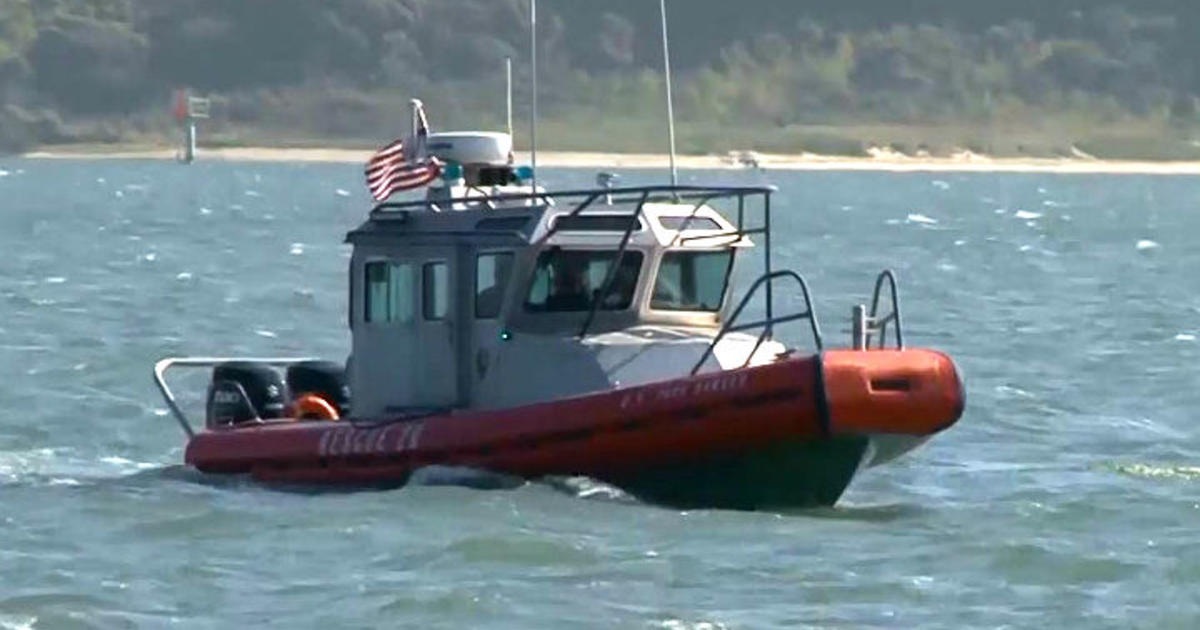
Crowds gathered at the Santa Cruz Harbor in California to watch the rising and falling water strain boat ties on docks. Law enforcement tried to clear people away when big surges started at around 7:30 a.m.
About an hour later, a surge went over the back lip of the harbor, filling a parking lot and low-lying streets and setting some cars afloat. In 2011 after the Japanese earthquake a series of surges cost $20 million of damage in the harbor.
Although experienced surfers would consider the waves reaching the West Coast barely high enough to qualify as swells, the National Weather Service warned that tsunamis cause deceptive water surges powerful enough to pull people out to sea.
The National Weather Service issued the alert tweeting -- "The arriving tsunami will come in pulses of surging water levels onto and off of the coast, similar to high tide. Do not expect to identify these arriving pulses by large cresting waves/surf. These water level surges can overwhelm and overtake people and pull them out to sea."
Waves with an additional 1-3 feet in height above normal are possible, officials warned.
During a live-streamed update on the National Weather Service Bay Area Twitter account, meteorologist Brian Garcia that the initial surge likely would not be the biggest surge as far as the waves arriving on the coast.
"All of the amplitudes we've seen so far have generally been in that [one to three foot] range. I think one site along the California coast has gone above that," Garcia explained, pointing out that the fourth surge that arrived at Point Reyes was the biggest surge yet after the initial surge.
Garcia warned that the increased wave size would continue well into the day Saturday.
"We should see the amplitude come down in the afternoon and late afternoon hours," Garcia said.
Vanessa Marlin was among a group of surfers who were watching the swells from San Francisco's Ocean Beach.
"It really doesn't look much different than it normally would on a Saturday or any given day at this end of the beach," she said. "It's definitely messy, but there are some peaks that could be surf able, but we're not going out today because it seems like it would be a bad idea with the tsunami advisory in effect. We're just appreciating the waves and the beauty that we see in front of us."
Flooding was reported near the Santa Cruz Harbor and some residents were evacuated. There were additional reports of over a dozen vehicles being completely submerged in the north harbor area of Santa Cruz.
Meanwhile, officials said more than 100 people were forced to evacuate at the Berkeley Marina. On the water near Mill Valley, the surging waters and high tides hit the dock and several boats broke free.
Nearby the Sausalito Police Department likened the tsunami's effects to "the worst king tide, but cycling many times over a few hours."
The weather service tweeted: "This is particularly important for people just waking up who may not check the news or social media before departing on their morning walk on the beach. Please consider calling your loved ones if you know they are currently on the coast to inform them of the hazard."
The San Leandro police issued a warning.
"Extensive flooding is not expected at this time, but damaging wave activity could occur within harbors and marina," the warning read. "Although large waves or extensive flooding is not expected to occur in area, we are advising residents to avoid waterways until the advisory has been cancelled because the waves could still pose a hazard to boats and swimmers."
Watch Live: Santa Cruz Harbor Webcam
San Francisco emergency service officials also issued an alert.
"A Tsunami Advisory means strong, dangerous currents are expected to impact San Francisco beaches, harbor and marina docks, and finger piers in shoreline areas," the warning read. "Dangerous currents are expected to begin at 8:10am, and may last for many hours."
The Golden Gate National Park Service tweeted a warning and officially closed all beaches and access points until further notice.
The surge arrived in the Hawaiian Islands at around 6 a.m.
"A tsunami is currently being observed by all Islands' Emergency Management," the weather service tweeted. "We are relieved that there is no reported damage and only minor flooding through-out the islands."
Brooke Bingaman was at Del Monte Beach.
"Tsunami energy arriving at Del Monte Beach," she posted. "Wave run up onto the beach is impressive. I'm safely distanced, but I saw other folks have to scramble when the waves unexpectedly reached them."
The eruption cut the internet to Tonga, leaving friends and family members around the world on Sunday still anxiously trying to get in touch to figure out if there were any injuries and the extent of the damage. Even government websites and other official sources remained without any updates.
Satellite images showed a huge eruption, with a plume of ash, steam and gas rising like a mushroom above the blue Pacific waters. A sonic boom could be heard as far away as Alaska.
Tsunami advisories were issued for Hawaii, Alaska and the U.S. Pacific coast. The U.S. Geological Survey estimated the eruption caused the equivalent of magnitude 5.8 earthquake. Scientists said tsunamis generated by volcanoes rather than earthquakes are relatively rare.
The Tonga Meteorological Services said a tsunami warning was declared for all of the archipelago, and data from the Pacific tsunami center said waves of 80 centimeters (2.7 feet) were detected.
Rachel Afeaki-Taumoepeau, who chairs the New Zealand Tonga Business Council, said she hoped the relatively low level of the tsunami waves would have allowed most people to get to safety, although she worried about those living on islands closest to the volcano. She said she hadn't yet been able to contact her friends and family in Tonga.
"We are praying that the damage is just to infrastructure and people were able to get to higher land," she said.
Tonga gets its internet via an undersea cable from Suva, Fiji, which presumably was damaged. All internet connectivity with Tonga was lost at about 6:40 p.m. local time, said Doug Madory, director of internet analysis for the network intelligence firm Kentik.
Southern Cross Cable Network, the company that manages the connection, does not know yet "if the cable is cut or just suffering power loss," chief technical officer Dean Veverka said.
The Fiji-based Islands Business news site reported that a convoy of police and military troops evacuated Tonga's King Tupou VI from his palace near the shore. He was among the many residents who headed for higher ground.
On Tonga, home to about 105,000 people, video posted to social media showed large waves washing ashore in coastal areas, swirling around homes, a church and other buildings.
New Zealand's military said it was monitoring the situation and remained on standby, ready to assist if asked.
In Hawaii, the Pacific Tsunami Warning Center reported waves that measured half a meter (1.6 feet) in Nawiliwili, Kauai and 80 centimeters (2.7 feet) in Hanalei. The National Weather Service said there were reports of boats getting pushed up in docks, but the hazard diminished as the morning went on.
"We are relieved that there is no reported damage and only minor flooding throughout the islands," the tsunami center said, describing the situation in Hawaii. The tsunami advisory for the islands was lifted about 11 hours after the eruption more than 4,828 kilometers (3,000 miles) away.
In Tonga, a Twitter user identified as Dr. Faka'iloatonga Taumoefolau posted video showing waves crashing ashore.
"Can literally hear the volcano eruption, sounds pretty violent," he wrote, adding in a later post: "Raining ash and tiny pebbles, darkness blanketing the sky."
The explosion of the Hunga Tonga Hunga Ha'apai volcano was the latest in a series of dramatic eruptions.
Earth imaging company Planet Labs PBC had watched the island in recent days after a new volcanic vent there began erupting in late December.
Satellite images captured by the company show how drastically the volcano had shaped the area, creating a growing island off Tonga.
"The surface area of the island appears to have expanded by nearly 45% due to ashfall," Planet Labs said days before the latest activity.
Following Saturday's eruption, residents in Hawaii, Alaska and along the U.S. Pacific coast were advised to move away from the coastline to higher ground and to pay attention to specific instructions from their local emergency management officials, said Dave Snider, tsunami warning coordinator for the National Tsunami Warning Center in Palmer, Alaska.
"We don't issue an advisory for this length of coastline as we've done - I'm not sure when the last time was - but it really isn't an everyday experience," Snider said.
He said the waves slamming ashore in Hawaii were just under the criteria for a more serious tsunami warning.
"It looks like everything will stay below the warning level, but it's difficult to predict because this is a volcanic eruption, and we're set up to measure earthquake or seismic-driven sea waves," Snider said.
The first waves to hit the continental United States measured about a foot in Nikolski, Alaska, and 1.9 feet in Adak, Alaska. A wave of about 2.6 feet was observed in Monterey, California, according to the U.S. National Tsunami Warning Center.
Beaches and piers were closed across Southern California as a precaution. The National Weather Service tweeted there were "no significant concerns about inundation." Strong rip currents were possible, however, and officials warned people to stay out of the water.
Residents of American Samoa were alerted of a tsunami warning by local broadcasters as well as church bells that rang territory-wide Saturday. An outdoor siren warning system was out of service. Those living along the shoreline quickly moved to higher ground.
As night fell, there were no reports of any damage and the Hawaii-based tsunami center canceled the alert.
Authorities in the nearby island nations of Fiji and Samoa also issued warnings, telling people to avoid the shoreline due to strong currents and dangerous waves. In New Zealand, officials warned of possible storm surges from the eruption.
New Zealand's private forecaster, Weather Watch, tweeted that people as far away as Southland, the country's southernmost region, reported hearing sonic booms from the eruption. Others reported that many boats were damaged by a tsunami that hit a marina in Whangarei, in the Northland region.
Earlier, the Matangi Tonga news site reported that scientists observed massive explosions, thunder and lightning near the volcano after it started erupting early Friday. Satellite images showed a 3-mile-wide plume rising into the air to about 12 miles.
The Hunga Tonga Hunga Ha'apai volcano is located about 40 miles north of the capital, Nuku'alofa. In late 2014 and early 2015, a series of eruptions in the area created a small new island and disrupted international air travel to the Pacific archipelago for several days.
There is not a significant difference between volcanos underwater and on land and underwater volcanos become bigger as they erupt, at some point usually breaching the surface, said Hans Schwaiger, a research geophysicist with the Alaska Volcano Observatory.
With underwater volcanos, however, the water can add to the explosivity of the eruption as it hits the lava, Schwaiger added.
Before an explosion, there is generally an increase in small local earthquakes at the volcano but, depending on how far it is from land, that may not be felt by residents along the shoreline, Schwaiger said.
© Copyright 2022 CBS Broadcasting Inc. All Rights Reserved. The Associated Press and Bay City News contributed to this report